Monday, May 17, 2010

The Midwest

I picked up a load of sausages from Hillshire Farms (now a division of Sara Lee) in New London, Wisconsin (north of Oshkosh, west of Green Bay). The day was gray and rainy and the air heavy with the scent of smoke and pork flesh. It is not easy to tell the difference, on the exterior, between a food processing plant such as this one, and a plant that produces anything else, edible or not. It is all metal siding, pipes and fans and machines and docks to back into and load up.
I took said sausages to Tolleson, Arizona (part of the hideous Phoenix metro) to a Sara lee "Mixing" facility. A place like this takes products from all the various subsidiaries of a parent company and "mix" them and ship them out to warehouses and distribution centers, a sort of warehouse for warehouses, another middle man, more truck movement.
From New London I traveled southwest on US-151 a route that cuts a beautiful diagonal across the state of Wisconsin from Manitowoc on Lake Michigan (home to Manitowoc, makers of such dissimilar products as cranes and ice machines) through the capital at Madison, across the driftless zone, a relatively rugged area untouched by glaciation in the last ice age, and crosses the Mississippi into Iowa at Dubuque.

The Wisconsin state capitol at Madison.


A road cut exposing "prairie stone" in southwest Wisconsin.


Iowa farmland outside of Dubuque.


More Iowa farmland near Brooklyn.


The (possibly most ostentatious) state capitol at Des Moines.

Sunday, March 28, 2010

Ontario, not that one


But rather the one in California.
The one in the Inland Empire, that great swath of the eastern LA metro, just over the first set of hills, where the ground gets drier and the air hotter and the people more hispanic. You could call Ontario the "heart" of the Inland Empire, that is, if the Inland Empire could possibly have a heart. It is where the main airport for the area is, and there's a big mall, Ontario Mills. What is the deal with calling malls "mills?" Is it a misspelling? They can't possibly have anything to do with mills which make something, textiles, flour, gunpowder, feed, puppies. Malls don't make anything, except money.
Anyway, Ontario is where i went to orientation for this new job. It is essentially a big plot of land covered in featureless warehouses and factories that crank out shit, or dole out shit. The only feature of these warehouses is their logo and so you see great white boxes with names like MagLight or JensenUSA (a bike parts distributor) or Fender or Louisville Slugger. Like its neighbors, Fontana and Mira Loma and Rancho Cucamonga, it is utterly congested with trucks.

Winter in the Inland Empire


An abandoned vineyard in a single block surrounded by warehouses.


An Elephant Statue in the Safari Business Park, Ontario, California

Sunday, March 21, 2010

Superstition Mountains


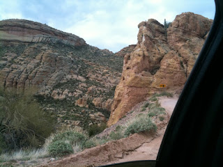
Before we get to the trucking a few photos from the Superstition Mountains. When I first got into to Tempe I headed with some friends up to the Superstitions Mountain, a range just to the east of the Phoenix metro They are a popular destination for Phoenicians (?) trying to flee the misery of their awful city. I had a pretty low opinion of Arizona (except maybe the whole Grand Canyon thing) but that is because I am thinking of the (completely unacceptable) urban areas and not of the (completely sublime) rural areas. We headed east on US-60, the Superstition Highway (ohhhhhh) out to Apache Junction and then hit the Apache Trail toward the town of Tortilla Flat, the least populated town in Arizona with a zip code. Essentially it appeared to be a false front western sort of place that was a store and a restaurant and a tourist trap. In a dip just beyond Tortilla Flat the pavement ended and the Salt River (or a tributary thereof), full from the recent rains, flowed over the road. A sign warned against crossing in such conditions but we said fuck it and headed over. The road narrowed and became a harrowing single lane track along the side of a mountain with a scrap of a guard rail that was more a visual barrier than any sort of physical one. Not to far up the road we pulled off and hiked up Fish Creek canyon a ways. It was a scrambly sort of hike and a lot of fun. So Pictures...


again, again, againagain

back on the road friendos.
After delivering produce throughout Western Washington for 8 months I have returned to the long haul. The produce gig was interesting and it was fascinating to see another leg in the journey of our food from farm to table. I delivered produce to supermarkets and restaurants throughout the Puget Sound region. My first routes took me to Top Foods locations in the Seattle metro and after I while i "graduated" to deliveries further afield, typically to Bellingham and Blaine (a town north of Bellingham right on the Canadian border) and on the occasional weekend would make the run to the miserable town of Aberdeen (birthplace of Kurt Cobain) and the town of Ocean Shores to the west. All of these routes were at night, usually starting at 6am and getting off sometime between 2 and 5am. I spent most of the time in Seattle being excruciatingly tired and looking back on that time I was constantly in some sort of zombiefied haze. but it was nice.

It is time now to get back to the business of making money to start this other business and that can't be done making the money i was making at the produce job or working a job where paying rent was required. My initial plan was to switch to a long haul job and spend my weekends alternately in Seattle and Maryland (where the bread oven (and my parents) are) but when I called to finalize plans with the long haul company it turns out they had just instituted a hiring freeze in he Pacific Northwest. Turns out they did not have enough freight in that neck of the woods to get their current drivers who lived in Washington and Oregon home and they were not keen on having more. At first I thought, well fine I'll just change my driver's license back to Maryland and that's that but I wanted to make sure I wasn't going to be relegated to the East both for the variety and the miles and so, having some friends in Arizona, I "moved" there. I shipped off most of my stuff via mail (i don't have a lot of stuff) and the rest came with me on a motorcycle down the coast and into the desert. It was a nice ride on which I will elaborate later.
I got my Arizona license and a few days later headed to orientation in Ontario, California via the always delightful Greyhound.
I wasn't sure I would continue blogging but at least one person wants me to and in their request referred to this as a "Photo Blog" which made me think, i can do that, just photos. less writing. so here you go.

Sunday, June 14, 2009

San Rafael Swell


First off it is Rafael. I spelled it Raphael in an earlier post and that is just wrong.

The San Rafael Swell is a desolate area of eroded beauty in central Utah. All of Utah could really be called an area of eroded beauty (though certainly not of eroded morals) but the Swell, pretty much smack in the middle of the state is exceptional.

Lets begin with geology. Simplistically land is made up of layers of sediment and then sometimes these layers are lifted up, or pushed down or cut through by water and wind. Though this is the case pretty much everywhere it is easiest to see out west since there is less of that pesky vegetation covering everything up.
Utah's layers (the layers of the Colorado plateau) were deposited successively by differing processes over the eons. At points Utah was the floor of a great sea and the sediments are those of shell and other calcium rich substances (limestone) other times it was the edge of the sea and there are layers of sand that has been compressed into cohesive strata (sandstone) and other times it might be hardened lava or volcanic ash. Tectonic forces pushed up the area known as the Colorado Plateau (which consists of parts of the four corners states, Arizona, Utah, Colorado, New Mexico) in a relatively uniform block (as opposed to being folded or subducted into mountains.) The San Rafael Swell is an uplift upon this uplift. Structurally you could think of it as many blankets layered over a trampoline (the blankets are the successive rock layers). Then forces pushed up on the bottom of the trampoline resulting in a layered dome structure.
Any time land is lifted up water that falls on that land will want to move down to lower elevations and when it does so it will erode the rock along with it. In the southwest the climate is usually very dry and when it does rain it tends to rain a lot and the soils, as dry as they are, cannot absorb any of this water and you end up with catastrophic floods that have even more erosive power. As such you get great gorges and canyons cut through the strata which are very scenic (National Parks on the Colorado Plateau include: Canyonlands, Arches, Capital Reef, Bryce Canyon, Zion and Grand Canyon)(I went on a road trip with my sister a few summers ago that included visits to all of these parks and by the time we were done I decided I was pretty cashed out on erosion and ready to see some volcanoes.)
The San Rafael Swell is so cut through and erratically eroded that it is quite difficult to travel across and, in fact, I-70 is the only paved road to cross it. Even then you have to wonder why since 70's western terminus is Cove Fort, Utah, which isn't much of a town. I suppose the reason would be to provide a link from the southwest (LA and Vegas on I-15) towards Denver, but still traveling 70 through Utah you have to think "this couldn't have been easy."

I-70 E following a canyon off of the swell.

Wrap up Posts

It has been a long time and I apologize. My excuse this time for the long absence will be the infernal Twitter. I have found it so easy to use my phone to snap pictures and quickly tweet them that it leaves me little inspiration for adding to the blog.
@truckermark is the name under which you will find my twittiness.

This will be the first in a series of wrap up posts on the experiences of trucking out west which perhaps has been so captivating that I have wanted only to soak it in and not immediately regurgitate it on these pages. At any rate now I will and that will be that.
Why, you ask? Well I have found myself a local trucking job delivering produce throughout western (and central) Washington state that will allow me to be home every day and that will be nice. I am not sure if it will provide fodder for blogging but if it does I will begin a new blog. In the mean time enjoy the following posts about the great western United States.

Tuesday, April 14, 2009

The Virgin River Gorge


I had picked up a load of imported Target merchandise from NYK Logistics in the LBC. For those of you not as "West Coast" as my self that's Long Beach, California, I will try and avoid thuggin out too hard henceforth.) This load of trinkets from Japan and China was headed to a Distribution Center in Pueblo, Colorado 1200 miles distant. Often there are multiple routes available to get from one point to another and many truckers just pick the Interstate, that uniform 4+ lane strip of dullness where the mountains are cut through and the valleys filled making travel through them easier, faster, and more unremarkable. Anyone who has driven across the country (or even any state) and found it dull did so on the interstate (or is just a hater, in which case, quit wasting gas.)
The back roads are often shorter, slower and almost invariably more interesting. Besides the towns and villages where you might encounter people smaller roads traverse terrain where building larger roads would be impossible or not cost efficient. i.e. prettier country. My advice, if you have the time, take the back roads.

HOWEVER, there are stretches of interstate with mind bending scenery. You can't avoid beauty that assiduously. Some such stretches are I-90 from Ellensburg to Seattle, Washington over Snoqualmie Pass in the Cascades (the only stretch of Interstate that is designated a national scenic byway), I-5 over the grapevine in Southern California, I-81 along the Blue Ridge in Virginia etc... Most of these roads clearly connect two important areas that need connecting an in so doing must surmount apparent obstacles (typically abrupt changes in elevation, mountains.) Some areas, however make you wonder why they would have ever put a interstate here, two such locations are ones that I had to travel to move this target shit to Colorado. I-15 through the Virgin River Gorge in the far northwestern Arizona and I-70 through the San Raphael Swell in central Utah.
The push to carve a highway in the Virgin River Gorge is more understandable as it connects Las Vegas and Los Angeles to the valley of the Great Salt Lake. There is an enormous elevation obstacle along this route in the name of the Colorado Plateau. I'm not going to get too geologically specific but suffice it to say this region, centered around the 4 corners area, was uplifted in millenia past by whatever it is that uplifts the earth. With all this elevation, and water still wanting, as it does, to flow down hill, gradually canyons were cut through this elevation creating the scenic amazements that are the Grand Canyon and the parks of Utah: Canyonlands, Bryce Canyon, Capital Reef and Zion. The Virgin River, which flows southwest out of Zion eventually tumbles off the plateau and into the Mojave Desert in so doing carving itself a nice canyon in the far northwest corner of Arizona (just to give you an idea of the elevation differential here, Vegas, down in the low hot Mojave, is at 2000 ft and Cedar City, UT is at over 5,800.
Naturally when looking for a way to mount this rise the interstate builders looked for a precut route and the Virgin River Gorge was just such a route. Nonetheless, mile for mile, it was one of the most expensive stretches of interstate. Some pictures:

Entering the Gorge


Curvyness


Up on the Plateau in Utah


In the next episode: The insanity that is The San Raphael Swell...